

Analysis: these names are real signifiers of our diverse native landscape and are shaped by local knowledge and past generations.
This article is now available above as a Brainstorm podcast. You can subscribe to the Brainstorm podcast through Apple Podcasts, Stitcher, Spotify or wherever you get your podcasts.
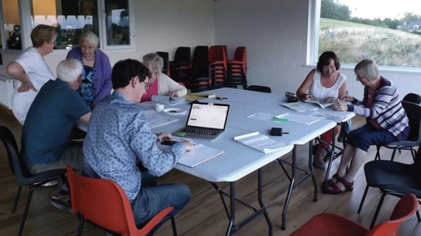
On a damp February night, 10 people have gathered in the lounge bar of Watty's Rock in Finea, Co. Westmeath. 'Go a hundred yards up that road and you’re in Ulster’ says one. The men, mostly farmers, have gathered here to record field names and other local placenames, most of which have never been written down anywhere.
The names which seem to stick out most are those of places whose physical signatures have been erased from the landscape. ‘Caltra, it was a hill, a sharp splint of a hill… it is a massive great hole now, and a hole deeper than it ever was high’. Caltra comes from Irish cealtrach ‘old burial ground’, and indeed human remains were discovered here in the 1960s, when quarrying works began.
The name and the memory of the hill live on to those few who knew it, but another generation will see such local knowledge disappear. The names are real. They are real signifiers of the landscape, shaped by the local community and the past generations which made it.
From Westmeath County Council, Dr Aengus Ó Fionnagáin discusses the Westmeath Field Names Project
The Westmeath Field Names Project was set up in 2018 and the community-led project is one of many which have sprung up all over Ireland in recent years. Tonight, names are being recorded with pen and paper; maps of townlands and project record sheets are spread-out across the lounge tables, and pored over.
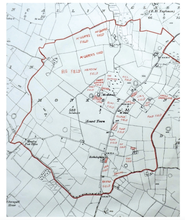
English names of long standing are common too, such as The Lawn, The Ram Park, The Calf Park and The Fallow Park being typical around the larger farmhouses. Each name provokes a lively discussion. A good internet connection and access to aerial photography helps to confirm each location. At the end of the night, the project coordinator records audio snippets, featuring each Irish name, for future reference.
As these names are being recounted, each with its own relation to house and farmyard, another place emerges in passing, ‘oh that’s down towards Ard na Muc’. This one seems well known to all present. Ard na Muc ‘the height of the pigs’, is a mere bend in a country road, lined on one side with bungalows. Despite the modest incline, the area offers fine views of the surrounding countryside. There must have been a story – perhaps a black pig roamed here. In many of the 14 communities across the county where names have been collected, a ‘valley of the Black Pig’, in one variation or another, has featured. Though the details of the story have been lost, the names remain in memory - just about.
Work in each area usually centres on an existing community group. First it was Taughmon-Turin Women's Group, and then the Drumraney Heritage Society. Word soon reached neighbouring Ballymore Heritage Group and from there spread out to the Collinstown Action Group and then Fore Heritage & Amenity Group (an element of local rivalry can be helpful!).
Tang Muintir na Tíre and Multyfarnham Active Retirement Association followed, as well as many others in places such as Boher, Ballinahown, Glasson, Kinnegad, Rochfordbridge, Loughnavalley, Rosemount, Mount Temple, Coole, Carrickobrien, and in 2024, Coosan and Finea.
The meetings attract young and old, male and female, people born and reared in the area with roots going back many generations, newcomers and longterm residents of all sorts. The ideal mix is one of the curious and the knowledgeable. Questions are asked, townlands are delineated, and names and all sorts of other ancilliary information about the lie of the land are shared freely. A not infrequent refrain is ‘I never knew that and I’m living here 30 years’.
Sometimes, or so it seems, the process of airing and recirculating all this intimate inherited lore can be as invigorating for those involved as actually getting the names down on paper. The ultimate destination of the names collected is Meitheal Logainm.ie, an online searchable map where anyone can locate them.
The most consistent characteristic of the names collected to date is their diversity. There are English names such as The Hopyard, The Sawpit, The Buckstile and The Flash, the last being a former wetland. Surnames of long-departed families are another big category: Earley’s, Dolan’s, Nellie Cleary’s. As one collector remarked, ‘each farm is made up of five or six smaller places’. Sometimes, the field name, and maybe a few ‘auld walls’ are all that remains of these former homesteads.
Irish names are most often topographical: Liosachán, ‘little ringfort’; Croc Broc, ‘hill of the badgers’ (croc is a local form of cnoc); Páirc na hAbhann, ‘the river field’'; Crocna, perhaps from cnocnach ‘hilly place’ and Srath Muar, muar being a local form of mór ‘big’, and a srath is a broad expanse of low-lying land, usually by a stream. There are many English names which incorporate such special Irish terms for peculiarly local features and landscapes: Reid’s Curragh (from currach ‘marsh’), Ryan’s Srath, Larry’s Carraigín and so on. When the shift from Irish to English happened, English as people came to know it often lacked this finely-tuned and familiar vocabulary, and so the Irish words made the jump.
The project is now in its seventh year, almost 3,000 names have been collected and three reports have been published, with another in preparation. We hope to collect more names in the coming year so contact heritage@westmeathcoco.ie if you want to get involved.
The Westmeath Field Names Project (2018-24) is funded by The Heritage Council and Westmeath County Council.
Follow RTÉ Brainstorm on WhatsApp and Instagram for more stories and updates
The views expressed here are those of the author and do not represent or reflect the views of RTÉ